hacklink hack forum hacklink film izle hacklink marsbahisizmir escortsahabetpornJojobetcasibompadişahbetBakırköy Escortcasibom9018betgit casinojojobet

Tag: rain

  • Where has all the rain gone? Bone-dry October strikes much of US

    Where has all the rain gone? Bone-dry October strikes much of US

    A bone-dry October is pushing nearly half of the United States into a flash drought, leading to fires in the Midwest and hindering shipping on the Mississippi River.

    More than 100 different long-term weather stations in 26 states, including Alaska, are having their driest October on record, through Sunday, according to records by the Southern Regional Climate Center and Midwest Regional Climate Center. Cities that have had no measurable rain for October include New York, Houston, Dallas, Philadelphia, San Francisco and Sioux City, Iowa, along with normal dry spots such as Los Angeles, Las Vegas and Phoenix, National Weather Service records show.

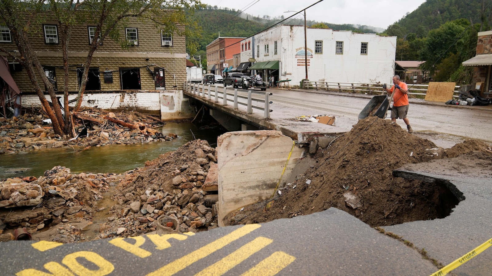
    “This is on pace for a record dry October,” said Allison Santorelli, acting warning coordinator for the National Oceanic and Atmospheric Administration’s Weather Prediction Center in College Park, Maryland. This includes the Southeast, some of which experienced deadly flooding just the month before in Hurricane Helene.

    In June, less than 12% of the country was experiencing drought. Now it’s almost 50% and growing, according to the U.S. Drought Monitor.

    That fits the definition of “flash drought,” which is different than normal slowly developing dry spells, said U.S. Department of Agriculture meteorologist Brad Rippey, a drought monitor author. A study last year showed that a warming world from the burning of coal, oil and gas is causing more frequent and damaging flash droughts, such as a $30 billion one that hit America in 2012 and a devastating 2022 drought in China.

    In one-eighth of the area of the continental United States, no rain has been reported for the first 28 days of October. About 93% of the continental U.S. is seeing below-average rain in October, most with less than an inch, according to climate center data analyzed by The Associated Press.

    Cities like Washington are forecast to hit 80 degrees on Halloween, right after Chicago and Detroit flirt with those summer-like temperatures. “That’s wild” for the end of October, said meteorologist Ryan Maue, a former chief scientist at NOAA who recalled trick-or-treating in snow in Michigan.

    Santorelli said a dome of high pressure has blocked moisture from moving north from the Gulf of Mexico, keeping dry much of the U.S. from the Plains and Midwest over to the Eastern seaboard.

    “We’ve been stuck in this blocking pattern for almost two months,” Rippey said.

    Studies the last decade or so have shown that the jet stream — the currents of air that move weather systems across the world — is wavier and getting stuck more often, attributing it to human-caused climate change’s extra warming of the Arctic, said Rippey. What’s happening now, especially with an extremely warm Arctic and “feverish ocean temperatures across the North Pacific,” fits the theory well, said Woodwell Climate Research Center senior scientist Jennifer Francis, one of the pioneers of the concept.

    Stuck weather systems this year have caused “weather whiplash” in places like Sioux City, where downpours in June caused so much rain that it pulled down a railroad bridge and forced people to their rooftops, said climatologist Melissa Widhalm, associate director of the Midwest Regional Climate Center at Purdue University.

    Asheville, North Carolina, which was devastated by Hurricane Helene, was deluged with nearly 14 inches of rain in three days in September, but has received only one one-hundredth of an inch in October.

    The Mississippi River, a major transporter of crops, is at levels so low that shipping loads have to be constrained, Rippey said. It’s the third straight year of problematic water levels on the river, he said. When Helene struck the Southeast and flooded North Carolina and Tennessee in late September, it provided a burst of fresh water that helped return Mississippi water levels to where they should be, but it didn’t last, Rippey said.

    It may hurt the transporting of agricultural products, but luckily for farmers the flash drought came in after harvesting corn and soybeans, Rippey said.

    But dry fields mean a situation ripe for wildfires in both the Midwest and East, Rippey said. Farm equipment has started a lot of fires accidentally, he said.

    Five large uncontrolled fires Tuesday had burned more than 1,000 acres in the East and Midwest, according to the National Interagency Fire Center.

    Relief is on the way for parts of the Midwest as storm systems from the West are forecast to break through with rain, sometimes heavy, Wednesday and Thursday, Santorelli said. But much of the East and Southeast look dry for another week, she said.

    __ Mary Katherine Wildeman in Hartford and Michael Phillis in St. Louis contributed to this report.

    __

    Read more of AP’s climate coverage at http://www.apnews.com/climate-and-environment

    ___

    Follow Seth Borenstein on X at @borenbears

    ______

    The Associated Press’ climate and environmental coverage receives financial support from multiple private foundations. AP is solely responsible for all content. Find AP’s standards for working with philanthropies, a list of supporters and funded coverage areas at AP.org.


    Source link

  • Hong Kong artist makes chocolate rain on New Jersey

    Hong Kong artist makes chocolate rain on New Jersey

    Maisie Ho (fourth from right), director of the Hong Kong Economic and Trade Office in New York, Prudence Mak (center), creator of Fatina Dreams and founder of Chocolate Rain, and other guests cut the ribbon at the exhibition in New Jersey. [PHOTO BY MINGMEI LI/CHINA DAILY]

    Prudence Mak says she hopes to inspire a connection between the Greater New York area and Hong Kong.

    The celebrated designer, who created the cartoon doll character Fatina Dreams for her creative crafts brand Chocolate Rain, told China Daily on Oct 12 that as a young woman from Hong Kong, she grew up in “a melting pot of cultures, where the East meets the West — it’s an integral part of who we are”.

    Fatina took center stage over the weekend at the Hong Kong Meets America — Pop Art Exhibition by Chocolate Rain at the American Dream Mall in East Rutherford, New Jersey, just across the Hudson River from Manhattan.

    This immersive event from Oct 11 to 12 — presented by the Hong Kong Economic and Trade Office in New York — offered visitors a unique opportunity to experience Hong Kong through interactive do-it-yourself workshops and artistic displays.

    Founded in 2000 by Mak, Chocolate Rain is popular for its designs inspired by childhood dreams and whimsical adventures.

    The brand also has previously been featured at New York City venues, such as the Museum of Modern Art and the Solomon R.Guggenheim Museum, gaining international acclaim for its distinctive artistic style.

    This time, Mak’s art brought Hong Kong’s vibrant street food culture and landmarks to life alongside similar scenes from New York. She noted the similarities between the two cities — both vibrant and fast-paced, with towering skyscrapers.

    Mak features iconic landmarks in her 3D artworks, such as the Statue of Liberty and yellow cabs of New York, alongside Hong Kong’s Big Buddha and the Star Ferry that crosses Victoria Harbor.

    She says that while she brought Fatina this time, she also has a deep appreciation for traditional Chinese art.

    “I personally practice art with the bamboo brush. I remember my grandpa …would come home and practice calligraphy with me. That’s how I was introduced to ink and brush for the first time. Art is for every lifestyle,” she says.

    Mak says she hopes to create a platform, especially for children, where people can engage with art through their own creativity. She says that both Hong Kong and New York are rich in art and creativity.

    “All of the 18 different districts around Victoria Harbor have public artwork installations. We are just one of them. There are over 20, 30 public installations, so it’s a beautiful, nice scene there,” says Mak.

    “And then also you can enjoy art. Hong Kong is a tiny gem. We call it a little pearl, right?” she says. “Sometimes, maybe you pass by, you miss it, because China has so many things, but don’t forget Hong Kong.”

    Maisie Ho, the director of the HKETONY, told China Daily: “We are excited to share a facet of Hong Kong’s culture with the American audience through our partnership with Chocolate Rain. This exhibition beautifully melds tradition with contemporary aesthetics, celebrating the vibrant creativity of our homegrown talent in the United States.

    “We wanted to bring Chocolate Rain here just to remind us of the joy they have in their hearts,” she says. “Culture can do that — linking the hearts between the two peoples. People also have a lot of passion for Hong Kong — Hong Kong food and Hong Kong icons.”

    Ho invited people to visit Hong Kong to try authentic offerings such as pineapple buns, egg tarts and dim sum, and to explore the city, which offers experiences that may seem familiar to Americans yet are uniquely Hong Kong in style, reflecting its distinct place in Chinese culture.

    “There are lots of similarities between Hong Kong and the US. I encourage everybody to either discover or rediscover Hong Kong,” she says, adding that visitors will be amazed by the latest developments to the city, and China has been welcoming to international visitors.

    Source link

  • Climate change gave significant boost to Milton’s destructive rain, winds, scientists say

    Climate change gave significant boost to Milton’s destructive rain, winds, scientists say

    Human-caused climate change intensified deadly Hurricane Milton ‘s rainfall by 20 to 30% and strengthened its winds by about 10%, scientists said in a new flash study. The analysis comes just two weeks after Hurricane Helene devastated the southeastern United States, a storm also fueled by climate change.

    World Weather Attribution researchers said Friday that without climate change, a hurricane like Milton would make landfall as a weaker Category 2, not considered a “major” storm, instead of a Category 3.

    WWA’s rapid studies aren’t peer-reviewed but use peer-reviewed methods. The WWA compares a weather event with what might have been expected in a world that hasn’t warmed about 1.3 degree Celsius since pre-industrial times.

    The team of scientists test the influence of climate change on storms by analyzing weather data and climate models, but in the case of Milton — which followed so shortly after Helene — the researchers used only weather observations data. WWA said despite using different approaches, the results are compatible with studies of other hurricanes in the area that show a similar hurricane intensity increase of between 10 and 50% due to climate change, and about a doubling in likelihood.

    “We are therefore confident that such changes in heavy rainfall are attributable to human-caused climate change,” said WWA, an international scientist collaborative that launched in 2015 and conducts rapid climate attribution studies.

    At least eight people died in Milton, which spread damage far and wide even though it didn’t directly strike Tampa as feared. Roadways flooded and dozens of tornadoes tore through coastal areas. At one point power was out to some 3.4 million customers, and more than 2.4 million remained without power Friday morning.

    Milton made landfall Wednesday evening as a Category 3 hurricane on the west coast of Florida near Siesta Key, about 70 miles (112 kilometers) south of the Tampa Bay area, driven by warmer waters near record levels.

    Climate scientist Michael Mann said he agrees with the thrust of the analysis that climate change substantially worsened the hurricane. But if anything, Mann said, the study might “vastly understate the impact that it actually had” with what he called “the fairly simple approach” of its estimates.

    He cited other attribution studies after Helene that calculated significantly larger rainfall due to warming.

    “It’s the difference between a modest effect and a major effect,” Mann, of the University of Pennsylvania, told The Associated Press. “I would argue that the catastrophic flooding we saw over large parts of the southeastern U.S. with Helene was indeed a major effect of human-caused warming.”

    Another analysis, done by research organization Climate Central, said earlier this week that climate change made possible the warmed water temperatures that amplified Milton. Andrew Pershing, the group’s vice president for science, said those waters were made up to 200 times more likely with climate change. The group said waters were more than 1.8 degrees F (1 degrees C) warmer than the 1991 to 2020 average.

    Together with Helene, which hit six states, the two storms made an otherwise unusually quiet hurricane season roar to life.

    ___

    Read more of AP’s climate coverage at http://www.apnews.com/climate-and-environment

    ___

    The Associated Press’ climate and environmental coverage receives financial support from multiple private foundations. AP is solely responsible for all content. Find AP’s standards for working with philanthropies, a list of supporters and funded coverage areas at AP.org.

    Source link

  • Climate change boosted Helene’s deadly rain and wind and scientists say same is likely for Milton

    Climate change boosted Helene’s deadly rain and wind and scientists say same is likely for Milton

    Human-caused climate change boosted a devastating Hurricane Helene ‘s rainfall by about 10% and intensified its winds by about 11%, scientists said in a new flash study released just as a strengthening Hurricane Milton threatens the Florida coast less than two weeks later.

    The warming climate boosted Helene’s wind speeds by about 13 miles per hour (20.92 kilometers per hour), and made the high sea temperatures that fueled the storm 200 to 500 times more likely, World Weather Attribution calculated Wednesday from Europe. Ocean temperatures in the Gulf of Mexico were about 3.6 degrees Fahrenheit (2 degrees Celsius) above average, WWA said.

    “Hurricane Helene and the storms that were happening in the region anyway have all been amplified by the fact that the air is warmer and can hold more moisture, which meant that the rainfall totals — which, even without climate change, would have been incredibly high given the circumstances — were even higher,” Ben Clarke, a study co-author and a climate researcher at Imperial College London, said in an interview.

    Milton will likely be similarly juiced, the authors said.

    The scientists warned that continued burning of fossil fuels will lead to more hurricanes like Helene, with “unimaginable” floods well inland, not just on coasts. Many of those who died in Helene fell victim to massive inland flooding, rather than high winds.

    Helene made landfall in Florida with record storm surge 15 feet (4.57 meters) high and catastrophic sustained winds reaching 140 miles per hour (225.31 kilometers per hour), pummeling Georgia, the Carolinas, Tennessee and Virginia. It decimated remote towns throughout the Appalachians, left millions without power, cellular service and supplies and killed over 230 people. Search crews in the days following continued to look for bodies. Helene was the deadliest hurricane to hit the mainland U.S. since Katrina in 2005.

    Helene dumped more than 40 trillion gallons of rain — an unprecedented amount of water — onto the region, meteorologists estimated. That rainfall would have been much less intense if humans hadn’t warmed the climate, according to WWA, an international scientist collaborative that runs rapid climate attribution studies.

    “When you start talking about the volumes involved, when you add even just a few percent on top of that, it makes it even much more destructive,” Clarke said.

    Hurricanes as intense as Helene were once expected every 130 years on average, but today are about 2.5 times more likely in the region, the scientists calculated.

    The WWA launched in 2015 to assess the extent which extreme weather events could be attributed to climate change. The organization’s rapid studies aren’t peer-reviewed but use peer-reviewed methods. The team of scientists tested the influence of climate change on Helene by analyzing weather data and climate models including the Imperial College Storm Model, the Climate Shift Index for oceans and the standard WWA approach, which compares an actual event with what might have been expected in a world that hasn’t warmed about 1.3 degrees Celsius since pre-industrial times.

    A separate analysis of Helene last week by Department of Energy Lawrence Berkeley National Lab scientists determined that climate change caused 50% more rainfall in some parts of Georgia and the Carolinas, and that observed rainfall was “made up to 20 times more likely in these areas because of global warming.” That study was also not peer-reviewed but used a method published in a study about Hurricane Harvey.

    Kim Cobb, director of the Institute at Brown for Environment and Society, wasn’t involved in either study. She said there are uncertainties in exactly how much climate change is supercharging storms like Helene, but “we know that it’s increasing the power and devastation of these storms.”

    She said Helene and Milton should serve “as a wake up call” for emergency preparedness, resilience planning and the increased use of fossil fuels.

    “Going forward, additional warming that we know will occur over the next 10 or 20 years will even worsen the statistics of hurricanes,” she said, “and we will break new records.”

    Analysis is already indicating climate change made possible the warmed sea temperatures that also rapidly intensified Milton. Clarke said the two massive storms in quick succession illustrates the potential future of climate change if humans don’t stop it.

    “As we go into the future and our results show this as well, we still have control over what trajectory this goes in as to what risks we face in the future, what costs we pay in the future,” he said. “That just hinges on how we change our energy systems and how many more fossil fuels we burn.”

    ___

    Read more of AP’s climate coverage at http://www.apnews.com/climate-and-environment

    ___

    Alexa St. John is an Associated Press climate solutions reporter. Follow her on X: @alexa_stjohn. Reach her at ast.john@ap.org.

    ___

    The Associated Press’ climate and environmental coverage receives financial support from multiple private foundations. AP is solely responsible for all content. Find AP’s standards for working with philanthropies, a list of supporters and funded coverage areas at AP.org.


    Source link

  • Here’s how Helene and other storms dumped a whopping 40 trillion gallons of rain on the South

    Here’s how Helene and other storms dumped a whopping 40 trillion gallons of rain on the South

    More than 40 trillion gallons of rain drenched the Southeast United States in the last week from Hurricane Helene and a run-of-the-mill rainstorm that sloshed in ahead of it — an unheard of amount of water that has stunned experts.

    That’s enough to fill the Dallas Cowboys’ stadium 51,000 times, or Lake Tahoe just once. If it was concentrated just on the state of North Carolina that much water would be 3.5 feet deep (more than 1 meter). It’s enough to fill more than 60 million Olympic-size swimming pools.

    “That’s an astronomical amount of precipitation,” said Ed Clark, head of the National Oceanic and Atmospheric Administration’s National Water Center in Tuscaloosa, Alabama. “I have not seen something in my 25 years of working at the weather service that is this geographically large of an extent and the sheer volume of water that fell from the sky.”

    The flood damage from the rain is apocalyptic, meteorologists said. More than 100 people are dead, according to officials.

    Private meteorologist Ryan Maue, a former NOAA chief scientist, calculated the amount of rain, using precipitation measurements made in 2.5-mile-by-2.5 mile grids as measured by satellites and ground observations. He came up with 40 trillion gallons through Sunday for the eastern United States, with 20 trillion gallons of that hitting just Georgia, Tennessee, the Carolinas and Florida from Hurricane Helene.

    Clark did the calculations independently and said the 40 trillion gallon figure (151 trillion liters) is about right and, if anything, conservative. Maue said maybe 1 to 2 trillion more gallons of rain had fallen, much if it in Virginia, since his calculations.

    Clark, who spends much of his work on issues of shrinking western water supplies, said to put the amount of rain in perspective, it’s more than twice the combined amount of water stored by two key Colorado River basin reservoirs: Lake Powell and Lake Mead.

    Several meteorologists said this was a combination of two, maybe three storm systems. Before Helene struck, rain had fallen heavily for days because a low pressure system had “cut off” from the jet stream — which moves weather systems along west to east — and stalled over the Southeast. That funneled plenty of warm water from the Gulf of Mexico. And a storm that fell just short of named status parked along North Carolina’s Atlantic coast, dumping as much as 20 inches of rain, said North Carolina state climatologist Kathie Dello.

    Then add Helene, one of the largest storms in the last couple decades and one that held plenty of rain because it was young and moved fast before it hit the Appalachians, said University of Albany hurricane expert Kristen Corbosiero.

    “It was not just a perfect storm, but it was a combination of multiple storms that that led to the enormous amount of rain,” Maue said. “That collected at high elevation, we’re talking 3,000 to 6000 feet. And when you drop trillions of gallons on a mountain, that has to go down.”

    The fact that these storms hit the mountains made everything worse, and not just because of runoff. The interaction between the mountains and the storm systems wrings more moisture out of the air, Clark, Maue and Corbosiero said.

    North Carolina weather officials said their top measurement total was 31.33 inches in the tiny town of Busick. Mount Mitchell also got more than 2 feet of rainfall.

    Before 2017’s Hurricane Harvey, “I said to our colleagues, you know, I never thought in my career that we would measure rainfall in feet,” Clark said. “And after Harvey, Florence, the more isolated events in eastern Kentucky, portions of South Dakota. We’re seeing events year in and year out where we are measuring rainfall in feet.”

    Storms are getting wetter as the climate change s, said Corbosiero and Dello. A basic law of physics says the air holds nearly 4% more moisture for every degree Fahrenheit warmer (7% for every degree Celsius) and the world has warmed more than 2 degrees (1.2 degrees Celsius) since pre-industrial times.

    Corbosiero said meteorologists are vigorously debating how much of Helene is due to worsening climate change and how much is random.

    In a quick analysis, not peer-reviewed but using a method published in a study about Hurricane Harvey’s rainfall, three scientists at the Department of Energy’s Lawrence Berkeley National Lab determined that climate change caused 50% more rainfall during Helene in some parts of Georgia and the Carolinas.

    For Dello, the “fingerprints of climate change” were clear.

    “We’ve seen tropical storm impacts in western North Carolina. But these storms are wetter and these storms are warmer. And there would have been a time when a tropical storm would have been heading toward North Carolina and would have caused some rain and some damage, but not apocalyptic destruction. ”

    ___

    Follow AP’s climate coverage at https://apnews.com/hub/climate

    ___

    Follow Seth Borenstein on Twitter at @borenbears

    ___

    Associated Press climate and environmental coverage receives support from several private foundations. See more about AP’s climate initiative here. The AP is solely responsible for all content.


    Source link

  • PHOTOS: Hoosier fans support IU football despite the rain

    PHOTOS: Hoosier fans support IU football despite the rain

    092928-iufans0002.jpg

    An Indiana fan plays cornhole Sept. 28, 2024, at the tailgating fields in Bloomington. Lots of fans at the tailgate fields brought ponchos and umbrellas to keep dry.

    092928-iufans0004.jpg

    An Indiana fan plays beersbee Sept. 28, 2024, at the tailgating fields in Bloomington. In his email to students, head football coach Curt Cignetti told students, “The tailgates can wait,” encouraging students to come into the stadium and support the team.

    092928-iufans0001.jpg

    An IU fan holds an umbrella while tailgating Sept. 28, 2024, outisde Memorial Stadium in Bloomington. Fans still showed up to tailgate before the Indiana versus Maryland game despite the weather.

    092928-iufans0007.jpg

    The IU student section is seen at the IU versus Maryland game on Sept. 28, 2024, at Memorial Stadium in Bloomington. The student section was filled top to bottom by the third quarter of the game.

    092928-iufans0014.jpg

    IU fans cheer on the team during the IU versus Maryland game on Sept. 28, 2024, at Memorial Stadium in Bloomington. Head coach Curt Cignetti wrote a letter telling students, “If you need to study, that can wait too,” trying to get more students to come support the team.

    092824IUvsMarylandFootball013

    The Indiana student section cheers on the Hoosiers in a game against Maryland on Sept. 28, 2024, at Memorial Stadium in Bloomington. The Hoosiers defeated the Terrapins 42-28.

    092928-iufans0006.jpg

    An IU fan holds up her baby Sept. 28, 2024, at Memorial Stadium in Bloomington. The fan was trying to get her baby on the big screen for the “Simba Cam.”

    092928-iufans0005.jpg

    Hoosier fans cheer on the IU football team Sept. 28, 2024, at Memorial Stadium in Bloomington. After the Hoosiers won the game, head football coach Curt Cignetti sent another email to students thanking them for showing up and asking them to do the same the next time the team plays at home.

    092928-iufans0012.jpg

    An IU fan sings during the IU versus Maryland game on Sept. 28, 2024, at Memorial Stadium in Bloomington. The student was singing along to Journey’s “Don’t Stop Believin.”

    092928-iufans0015.jpg

    IU fans record themselves celebrating IU’s win over Maryland on Sept. 28, 2024, at Memorial Stadium in Bloomington. The student section was packed top to bottom until the game was over.

    092928-iufans0013.jpg

    IU fans yell into one the camera of one of their phones during the IU versus Maryland game on Sept. 28, 2024, at Memorial Stadium in Bloomington. Hoosier fans recorded themselves celebrating as the clock was winding down.

    092928-iufans0011.jpg

    The Indiana student section is pictured during the IU versus Maryland game on Sept. 28, 2024, at Memorial Stadium in Bloomington. “We need you there in the stands being loud for the first quarter,” head coach Curt Cignetti said in his letter to students, “and most importantly, in the fourth.”

    092928-iufans0016.jpg

    An IU student celebrates the Hoosiers win over Maryland on Sept. 28, 2024, at Memorial Stadium in Bloomington. IU students cheered “Hoosier Daddy” as Indiana gained the lead on Maryland.

    092928-iufans0017.jpg

    An IU fan wearing a swim cap and goggles celebrates Indiana’s win over Maryland on Sept. 28, 2024, at Memorial Stadium in Bloomington. After the game, Indiana players ran over to the student section to high five the spectators.


    Source link